

🌹A Dreamer’s Guide to the Rose City🌹
🌹A Dreamer’s Guide to the Rose City🌹
We begin with a loop around town and Portland’s own architectural rendition of “Beauty and the Beast.”


Welcome to Portland, Oregon! You may know us as PDX, the Rose City, Portlandia, Little Beirut, or Stumptown. We go by all those, I suppose.
I’m Jordan and I’m your guide. I grew up in Southeast and have an abiding passion for Oregon geography and lore. In this series, titled A Dreamer’s Guide to the Rose City, we’ll explore this special place together through stories both vast and personal.
Portland’s stature has boomed considerably over the last 20 years. In that span, we’ve been one of the nation’s fastest growing cities and consistently ranked as one of the best places to live. We’re renown for our gray and rainy skies, sportswear, exceptional food and drink, and our proximity to natural beauty. More recently, our tourism-centric core suffered through the pandemic and a summer of protests/riots. Then conservative news picked us to be their Mordor.
We do sit along the Ring of Fire, though, and we’re shaded by volcanos and layered over in forests which we’ve watched dry and burn. Every city is both mighty and fragile, and in this series, I hope to illustrate some of our complexities. Really, though, I just want to tell you about all the little places here which bubble up memories or make me feel home.
I also want this to be a shared chronicle, so if you’re local or ever have been, I hope you’ll share some of your own memories in the comments.
Let’s begin with a short road trip. This will give you an overview.
You are most likely arriving from the east, traveling westbound on I-84. Possibly you’ve been driving awhile and passed through the Gorge, but more likely you arrived at Portland International Airport and we’ve crossed through a middle swath of the east side and are now hurtling toward the center of town.

The westernmost stretch of I-84 dips down into Sullivan’s Gulch, a canyon channeling toward the Willamette. City streets pass overhead.
We are nearing the Freeway Loop, a clamorous combination of I-5 and I-405 which circles the central city, and crosses the Willamette River over two massive bridges. We have a choice to make. We can head left onto I-5 South, which spills into downtown over the Morrison Bridge or stretches in one mighty ribbon of concrete all the way to Mexico. We could drive the Loop in that direction, but views on the bridges will be blocked by beams and the views are the whole point here.
The better option is to follow I-5 North—the path to Canada—which begins by winding between the Rose Garden and the green glass spires of the Convention Center. By starting with the Rose Quarter, we can spot some of the city’s grandest sites in around fifteen minutes, then branch out to wherever we want to go.
The Rose Quarter is moderately scenic, especially if you like seeing sports arenas. From a God’s-eye view, ours is shaped like a rose, which is why I’m sticking with the original name and not some bland sponsored moniker. To the right is the glow of those twin spires and they always make me happy.
This stretch of I-5 also has the nasty distinction of having sliced Albina—one of North Portland’s central Black neighborhoods—in two. This fracturing of marginalized neighborhoods was a frequent byproduct of the interstate freeway builds of the mid 20th century. There are currently plans to cover I-5 and unite the neighborhood again, though it’s probably a good bet to expect more luxury highrises than affordable housing.
The Blazers play at the Rose Garden, and I once worked there for a bit.
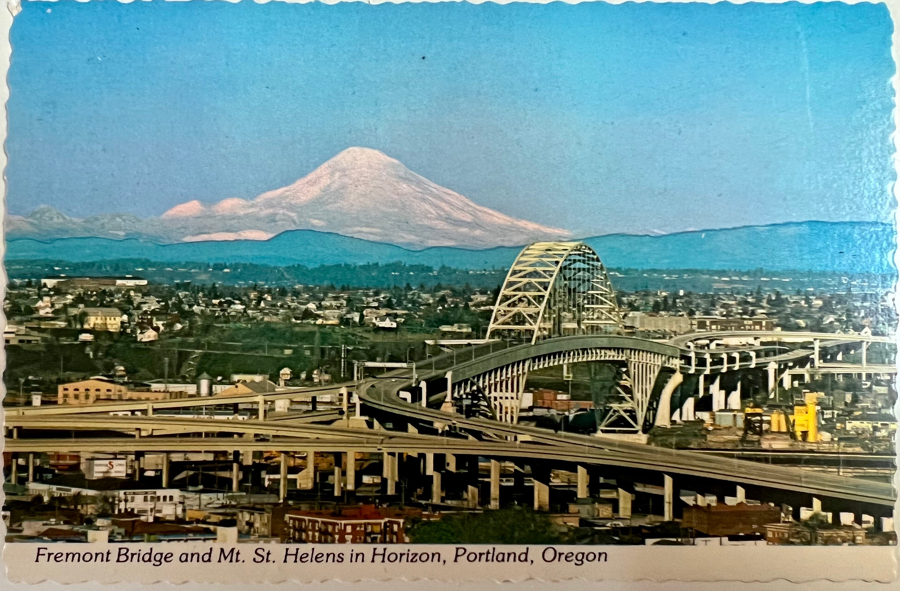
We emerge past the arena with a vista of North Portland industry off to the left. We can’t see the river, but we know it’s there because the Fremont Bridge and West Hills are hovering off in the background. The left lanes continue north toward the Columbia while the right lanes bank away to climb up and over I-5 and merge with the top deck of the Fremont.
Real quick, though, you see that hospital off to the right? That’s Emanuel, and that’s where I was born. Right under the helipad!
Beauty
When the Fremont Bridge was opened in 1973, it was the longest tied arch bridge in the world, and held that distinction for 34 years until the Caiyuamba Bridge was built across the Yangtze River. The elegant structure, reminiscent of skipping over the water, was inspired by the original Port Mann Bridge in British Columbia.
The Fremont’s magnificence is due in large part to backlash over the other bridge we’ll be driving over, the Marquam, which opened a few miles upriver in 1966, and was later described by Mayor Vera Katz as “…like having the Berlin Wall dividing east and west, with all the subtle charm of the Daytona 500, smack dab in the middle of our city.” Due to the public’s distaste, Governor Mark Hatfield promised to include the Portland Arts Council in future bridge designs.
The Fremont’s wide upper deck and towering arch create a vaulting effect, with the stacked arrows overhead pointing upward still. For being way up in the air, the top deck is strangely calm when traffic is flowing, especially as the bridge crests and a wider vista opens onto all the Northwest Quadrant’s industrial nooks and moneyed crannies. There are green hills and auto shops and churches and condominiums and so many lovely trees—the whole mass of Uptown arrayed in miniature around the splayed concrete. Off to the left are the glass and steel towers of the Pearl District, crescendoing southward toward the skyscrapers of Downtown. This is the view my wife Mindy claimed made her fall in love with Portland.
We could spill out here, down into the Northwest Quadrant, further along the west bank of the Willamette, past Sauvie Island and eventually on to Astoria and the Pacific. Instead, we will be banking south and into a long descent through the gap between Uptown and Downtown.
The view of the city grows more intimate as we descend, though traffic is often snarled through this stretch by travelers exiting toward Nob Hill or the Pearl or or Highway 26, which tunnels under the West Hills. If you stay in the left lane, though, you can often sail right through, and this stretch almost begins to resemble a garden, with curved freeway barriers draped in climbing vines, and medians lined with flowers.
Maybe I shouldn’t build this up too much because it’s still a freeway.
Then the road bends east again, back toward the river, and here is where it crosses through the other major neighborhood the freeways devastated: Lair Hill.
Lair Hill is still riddled with the Queen Anne-style homes built during the city’s boom in the Gilded Age. The area grew into working-class neighborhood, a haven for Jewish, German, and Eastern European immigrants working Downtown and at the shipyards and furniture makers along the South Waterfront. By the time the neighborhood was razed to build a freeway innerchange, Lair Hill Park was a hub of protest movements and counterculture. The neighborhood’s uprooted Jewish community mostly moved further south to the developing dairylands of Hillsdale.

The Beast
And now we have another choice to make, to head south and upland, toward the city’s southern suburbs, or we can continue over the Marquam—which is pronounced “markum” by the way—and finish this dang loop already!
I must confess something to you here: the Marquam is my favorite bridge. Even now I know how crazy that sounds, especially when I remember all the other bridges and my recollections of each, but the Marquam is so widely unloved that my contrarian heart rings aloud: Defend her! Defend the Marquam! For someday she will be gone!
Here are my reasons:
There’s a thrill to the Marquam, a mingling of danger with glory and scope. Could we possibly catapult over the medians and fall hundreds of feet to a watery doom? Might the Big One hit while we’re up here and the top deck collapse onto the lower, or a section fold down like what happened with the Bay Bridge in ‘89 as we find ourselves falling into oncoming traffic? Or maybe it’d just topple over? Yes maybe! And doesn’t that make you feel just a little more alive?
The Marquam is a basic double deck cantilever truss which has faithfully served as Oregon’s busiest river crossing for most of its 56 years. In form and cost, the bridge is reminiscent of the early days of the world’s greatest public works project, the Federal Highway Acts, signed into law by President Dwight Eisenhower. The laws set in motion a quest to develop interstate travel for Americans while also providing the nation with a strategic backbone similar to the German Autobahn. This fundamentally reshaped how we live and move.
Whether or not the bridge is technically defined as Heroic or Brutalist architecture, it was certainly cheap, public, and made of concrete. The Marquam was finished at around $14 million. By comparison, when the Fremont was completed seven years later, the price tag was $82 million.
And then there is the view. This is why we’re here in the first place.
Off to the right is the Willamette, widening to wrap around Ross Island. There are the angular white ribs of Tilikum Crossing, meant to mimic the outline of Wy’east (Hood). Ahead of us on the east bank is the red smokestack and blue glass pyramid of OMSI. Beyond that are the sprawling neighborhoods of the Eastside, a grid of domiciles running all the way out to the Cascades, broken by the green swells of Rocky Butte, Mount Tabor, Powell Butte, and Mount Scott. Looming beyond them all are the snowcapped ridges of Wy’East and his foothills.
To the left is the iconic waterfront image of Downtown, the green and brick vertical lifts of the Hawthorne Bridge, the river reflecting the towers and bridges and clouds and sky. As the lanes swing back to the north and drop down again toward the riverbank, the northern skyline is ahead again, the Rose Garden and Convention Center, only now backdropped by Loowit (St. Helens). We can see the low towers of the Lloyd District again, and the middle bridges bristling over the blue band of the Willamette.
There may be more prettier views, but there aren’t many more expansive, and they certainly aren’t available to all Oregonians on a daily basis. I like it best here on Sunday mornings, driving with my family when traffic is light, the visibility either clear or shrouded in fog.
If our final destination is on the Eastside, the I-84 exit will lead us out the way we came or drop us in close near the train tracks, where there are tons of fine restaurants and breweries. If we stay on the loop, though—perhaps go around for another run—we are now on the final leg, swooping down along the west bank of the river. This is the where the freeway runs closest to the water. The key to the view here is to look downriver as it bends away from I-5.
But wait! There’s one last point to consider, right before you rise back up to the calamity of the I-84 merger and remember how Albina was torn apart and a million Americans were displaced to create this epic river of concrete upon which we can all drive a faster than a mile a minute, almost for free, anywhere we want.
It’s right past the Burnside Bridge, a pint where if you’re looking down river, the black Steel Bridge and the rust-red Broadway and the Fremont’s bounding white arch converge into one shape, a Bridge City Voltron. When traffic’s light, this convergence is just for a moment, but I have learned to look for it every time.
This made me chuckle - "Maybe I shouldn’t build this up too much because it’s still a freeway." When we first moved to Portland and lived just north of 405 in NW, I was always amazed at the beauty of the vines and roses along that section of highway. I have hope that it will look like that again someday! -S
I’m gonna love this series! I wonder where my pictures of our 1990ish Ptld Bridge Adventure are??? Somewhere among Lewie & Joan’s, Vic Jr’s, Vic & Eva’s, and my own…. How’m I ever gonna get it all organized & accessible?
There are a lot of Portland shots in there— over 70 years’ worth.